
Does protected area status protect from fire in a Sumatran peatland ecosystem?
- ConScience

- May 20, 2022
- 5 min read
Updated: Sep 1, 2022
By Muhammad Ali Imron (Universitas Gadjah Mada, Indonesia) and Mark E. Harrison (University of Exeter), based on a recent open access paper published by our team in Frontiers in Forests and Global Change (available here).
Wildfires are becoming increasingly prevalent worldwide, owing to a combination of changes in climate, land use and disturbance, and human fire use. Consequently, the impacts of wildfires on climate emissions, biodiversity, public health and local economies are becoming increasingly felt. From moor fires in the UK, to the dry forests of Australia and California, tropical nations such as Brazil and Indonesia, and even the Arctic Circle, it is rare for more than a few months to pass without (the impacts of) wildfires somewhere in the world making international media headlines.
While regular fire is a natural feature in and can thus be beneficial for some ecosystems, increasing fire frequency and/or intensity as a result of human activities can create major problems, and many ecosystems rarely experience fire and so can be heavily damaged from fire events. One such ecosystem is tropical peatlands, which arise in areas of high rainfall and poor drainage, leading to the naturally swampy conditions that favour peat formation. In contrast to peatlands in places like the UK, tropical peatlands are typically forest ecosystems, which are home to abundant rainforest diversity, including globally threatened flagship species such as orangutans and the Sumatran tiger.
These swamps’ wet conditions serve as a natural fire guard, preventing fire from starting and spreading. It is perhaps therefore surprising that peat actually burns relatively easily when it does dry out, which now happens over large areas of South-east Asian tropical peatland during the dry season, owing to artificial drainage for agriculture and logging. The fires that do occur in these swamps are therefore highly damaging, causing high tree mortality, burning away the peat soil substrate and creating thick haze clouds, threatening biodiversity, climate and public health in the process. Recovery from these fires may therefore take many decades, particularly when highly disturbed areas have been burned multiple times.

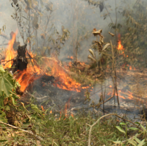


Peat fire in 2015 (left) and Dr Imron inspecting a smouldering peat fire around Padang Sugihan Wildlife Reserve, South Sumatra, Indonesia. Photos by: Hatma Suryatmojo.
Recognising the critical contribution that natural ecosystems play in addressing the ongoing global climate and biodiversity crises, there is increasing international momentum towards expanding the coverage of protected areas. This is exemplified by the High Ambition Coalition’s “30by30” call to protect 30% of our lands, rivers, lakes, and wetlands by 2030, and same for oceans, to which over 90 countries have signed up. Somewhat surprisingly, relatively few researchers have investigated the effectiveness of protected areas in reducing tropical peatland wildfire.
With this in mind, our research team set out to explore the patterns and causal factors of fires within and surrounding the Padang Sugihan Wildlife Reserve (PSWR), a protected tropical peatland area in South Sumatra, Indonesia. The 881 km2 reserve is dedicated for biodiversity conservation, in particular the critically endangered Sumatran elephant. The surrounding buffer area has experienced substantial disturbance, including construction of canals, roads and human settlements. Active fire data from the MODIS satellite was used to compare fire prevalence in the reserve and its surrounding 10 km buffer area over a 20-year period, from 2001 to 2020. The influence of rainfall, vegetation density, and distance to roads, canals and settlements was also assessed.


Left: Map of study area as of 2015, showing the canal and road networks within and surrounding Padang Sugihan Wildlife Reserve (PSWR) and the presence of settlements within a 10 km buffer of the reserve. From Imron et al. (2022). "Figure 1" by Imron et al. is licensed under CC BY 4.0 (https://creativecommons.org/licenses/by/4.0/). Right: A Sumatran elephant (Elephas maximus sumatranus) pictured in Tangkahan village near Mount Leuser National Park, also in Sumatra, Indonesia. Photo by: Nabila and Giot.
The results of this are detailed in a recent paper published in Frontiers in Forests and Global Change (available here), led by Universitas Gadjah Mada in Indonesia, and also involving scientists at Technische Universität Dresden, the Indonesian Nature Conservation Agency and University of Exeter.
In line with previous research in the region, we found that fire occurrence in both the reserve and buffer was most frequent during the dry season from July to November, with a one-month lag between the sharp drop in precipitation typically occurring in July and the onset of the main fire season. The highest annual fire incidence all occurred in El Niño years, which are associated with longer and more intense dry seasons in Indonesia.
Importantly, the reserve was effective in limiting fire compared to the surrounding buffer area only in wet years, with substantially higher fire spread into the reserve during dry years. Similar to other reports, we also found that peat fire occurrence in both the protected area and buffer zone was not due to climatic factors alone: distance from canals and roads also contributing significantly towards fire occurrence. This is unsurprising, given that canals drain the peat making it more vulnerable to fire, almost all tropical peatland fires are started by people (ignition from lightning strikes is rare), and access into these swamps is incredibly difficult in the absence of canals or roads.


Left: Canal system in tropical peatland near Padang Sugihan Wildlife Reserve, Sumatra. Photo by: Muhammad Ali Imron. Right: Predicted map of fire-risk probability class for La Niña (left) and El Niño (right) conditions, with risk represented by different colours ranging from red (high) to green (low). From Imron et al. (2022). "Figure 6" by Imron et al. is licensed under CC BY 4.0 (https://creativecommons.org/licenses/by/4.0/).
These findings suggests that protection can only go so far in preventing fire and even protected tropical peatland areas may still be vulnerable during drier, El Niño years. This may be especially so in areas such as PSWR, which is traversed by canals and where the surrounding buffer experiences high disturbance. In turn, this suggests that ongoing fire prevention and mitigation efforts will be required in protected tropical peatland areas in the region, particularly in cases where drainage remains an issue. It also suggests that fire prevention in protected tropical peatland areas must consider fire processes at a landscape level. This include consider not only the protected area itself, but also the surrounding (buffer) areas, in which fire may more commonly arise and spread into the protected area. Such measures will help increase the effectiveness of fire protection and, in so doing, conserve threatened tropical peatland wildlife such as the orangutan and Sumatran elephant.
This research was supported financially by the Lembaga Pengelola Dana Pendidikan, the
Indonesian Science Fund and the UKRI GCRF grant (No.: NE/T010401/1) held by the University of Exeter’s Prof. Frank van Veen for the Kalimantan Lestari project.


Comments